SYRACUSE, N.Y. ( NCC News) – Central New York is often known for crazy winters with massive snowfall, but summertime brings a different type of weather to the area. Although our summer doesn’t officially start until the June 21 solstice, for meteorologists today, June 1 , means it is officially hurricane season.
The meteorological summer is from June 1 to August 31 coinciding with the three warmest months of the year. The time frame is used as reputative standard data collection reference for meteorologist and others looking at atmospheric data. To the average Joe it is simply known as hurricane season.
What is hurricane season and when is it?
The warm conditions that are seen during these next few months create the perfect recipe for hurricanes to develop in the Atlantic Ocean. Starting off the coast of Africa and with ocean temperatures above 78 degrees storms begin to form picking up wind speed in a counterclockwise direction moving toward the west and into the Atlantic coast. The storms are fueled by the warm waters, as temps continue to rise north so do the storms.
Hurricane season officially runs during the meteorological summer but because storm conditions tend to still be ideal, the season runs all the way till October some years.
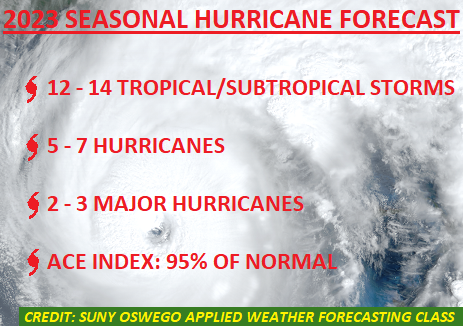
SUNY Oswego assistant professor Samuel Perugini teaches a class about weather forecasting. In this class students go through various projects that challenge them to forecast future weather patterns. One of Perugini’s assignments was to forecast this season hurricane outlook. The computer models from the class show that this year’s season should be about average along the East Coast. The students’ projections fall in line with the predictions from the National Hurricane Center in Florida.
What is the impact on Central New York?
Although it is unlikely, something like Hurricane Hazel from 1954 can make it all the way to upstate New York. Other hurricanes have made it to the area, but Hazel had the most impact. There still is concern about these storms even if the eye doesn’t directly hit Syracuse.
“It’s going to be a much weaker storm. (When it reaches CNY) However, it’s still going to have all that tropical moisture with it. So, you’re still going to have to deal with the torrential rainfall,” said Michael Kistner, lead meteorologist National Weather Service – Binghamton.
You may still think that a hurricane will never hit Central New York. You’re probably right, but meteorologists at the National Weather Service aren’t concerned about a hurricane going through Clinton Square. They’re concerned about the flash flooding that can be caused by leftover storms.
“As the water falls on those mountains. It’s all going to run off…that’s when you’re going to start seeing bad flash flooding and flash flooding occurs, fast,” Kistner said.
How fast?
“Any type of tropical system, whether it’s still named or not, can produce five to ten inches of rain in a very short period of time,” Perugini’s said.
Just six inches of heavy rain can begin to create havoc by sweeping away people, cars, roads and other lose materials.
The best course of action is to be prepared by keeping informed on where weather systems are and the impact that they could have on a given area. Having a disaster supplies kit also helps to be ready for when disasters arise.
If you are planning on vacationing on the East Coast this hurricane season, forecasters say to do it early when surges are less likely, but if you do go late in the season then be aware of systems moving in and either avoid going down to the area or leave the area as soon as local officials issue evacuation notices.