Syracuse, N.Y. (NCC News)— Gerry Vanderwater stood in Columbus Circle downtown in her scarf and coat on a sunny, yet chilly day for March in Syracuse. She thought back to what the snowfall was like when she grew up as a kid in the area, saying this year couldn’t compare.
“We used to have snowbanks twice as tall as I am right now,” Vanderwater said.
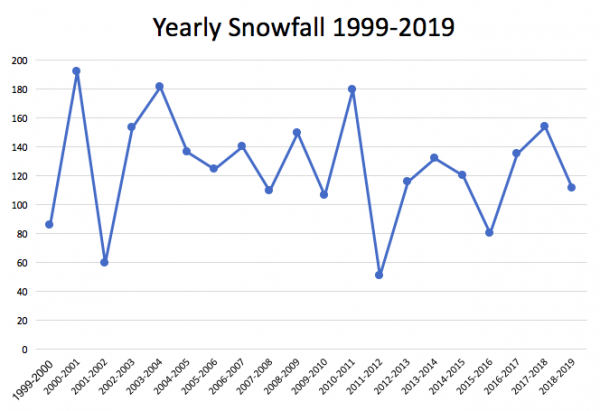
Snowfall in Syracuse to date is 12 inches below its yearly average and 42.5 inches behind last year’s total. With 111.1 inches for the 2018-19 season, this year ranks as the seventh lowest amount of snowfall in the past 20 years. Last year’s 153.6 inches ranked as the fourth highest.
Jared Klein, the science and operations officer at the National Weather Service in Binghamton, said fluctuations in snowfall are not unusual, but he did note some differences in this season’s storm patterns.
Klein said only two large storms hit Syracuse this season in November and January. There was also more storms that traveled west through the region in the direction of the Great Lakes that brought mixed types of precipitation.
“That means warmer air comes into the region and some of the events have been a wintry mix, so we’re talking about snow maybe changing to sleet or freezing rain or even rain,” Klein said.
Vanderwater was not the only one to notice a change in this year’s snowfall.
“I thought it was rather mild compared to what it’s been in several years,” said Janet Witter, Syracuse.
Meteorology professor Scott Steiger at the State University of New York at Oswego noted how “neat and changeable” the winter weather in central New York is. He recalled one storm that the SUNY-Oswego campus experienced in February.
“The south side of the campus got a foot of snow, and the north side of the campus got nothing,” Steiger said. “It’s amazing how local the weather is because of the lake [effect snow].”
Steiger speculated that residents may not see much more snow next year.
“Next winter there are some signs that El Niño will become strong and that could lead to a below normal snowfall for next year,” Steiger said.